Latest Route Maps August 2017
Updated maps can be download in vector PDF format on the Route Maps page.
Active Routes:

Including under construction Phase 3 routes:
Including under construction Phase 3 routes and proposed Phase 4 routes:

Filed under: Delhi Metro Maps | Leave a Comment
Tags: active routes, delhi metro, delhi metro map, delhi metro phase 3 map, delhi metro phase 4 map, operational routes
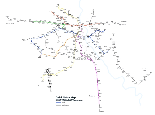
Phase 3 Route Maps Updated
I’ve updated my Phase 3 route maps to include the latest approved lines (Mundka-Bahadurgarh; Dwarka-Najafgarh; Yamuna Vihar-Shiv Vihar). They can be downloaded as .pdf files at the Route Map page, or as .svg files from Wikimedia Commons via the .svg page.
Phase 3 Route Map

.
Phase 3 Schematic Route Map

Filed under: Delhi Metro Maps | 1 Comment
Tags: delhi metro, delhi metro map, delhi metro phase 3 map, delhi metro phase III map, delhi metro route map, dmrc
I had long ago wanted to “complete” my photographing of Delhi Metro’s Phase II lines, and have finally been able to do that! Here are photos of the Yellow Line south of Rajiv Chowk (Patel Chowk and Central Secretariat stations were completed in Phase I).
.
Patel Chowk
Patel Chowk station entrances


.
Central Secretariat
Central Secretariat station entrance and government offices in the background


.
Jor Bagh & INA stations
Jor Bagh station entrance


.
AIIMS & Green Park stations
AIIMS station entrance with “Medical” in the background


.
Malviya Nagar and Saket stations
Malviya Nagar station entrance


.
Qutb Minar station


.
Chhatarpur and Sultanpur
Chhatarpur station


.
Ghitorni
Ghitorni station


.
Guru Dronacharya and Sikandarpur
Guru Dronacharya station


.
MG Road station


.
HUDA City Center station


Filed under: Delhi Metro Photos | 1 Comment
Tags: delhi metro, yellow line
Gurgaon’s own small metro rail is under construction to be ready by 2013, and will interchange with Delhi Metro at Sikandarpur station. Here are a few photos of Gurgaon Metro’s (officially Rapid Metro Rail Gurgaon) Sikandarpur station under construction.
.
Delhi Metro’s Sikandarpur station, in close proximity with Gurgaon Metro’s station construction site


Filed under: Delhi Metro Construction Photos | 1 Comment
Tags: construction photos, delhi metro, gurgaon metro, yellow line
Violet Line Construction Photos
The Violet Line is being extended as part of Delhi Metro’s Phase III expansion plan, both northwards from Central Secretariat to Kashmiri Gate, and southwards from Badarpur to Faridabad. These are photos of construction work along the northward extension.
.
Kashmiri Gate station
The existing Kashmiri Gate station serves the Red Line, and will become an interchange once the Violet Line extension is completed.


Kashmiri Gate on a Sunday morning

.
Red Fort station
This station is coming up along Netaji Subhash Marg, in front of the Red Fort.


.
Delhi Gate station
This station is coming up along Bahadur Shah Zafar Marg in front of Firoz Shah Kotla stadium.

.
ITO station
Also on Bahadur Shah Zafar Marg, near the ITO intersection.


.
Mandi House station
This will be an intersection between the Blue Line (with it’s existing station at Mandi House) and the Violet Line extension.


Filed under: Delhi Metro Construction Photos | 1 Comment
Tags: construction photos, delhi metro, violet line
Barakhamba Road Station
A few photos of Barakhamba Road station entrances.
.


Filed under: Delhi Metro Photos | Leave a Comment
Tags: blue line, delhi metro
Yellow Line Photos
New photos from the Yellow Line. These photos are from the northern end of this long line: Jahangirpuri, Azadpur, New Delhi (Railway Station) and a few others. These photos are also on flickr.
.
Jahangirpuri is the last station on the line (till 2016 anyway, when the line will be extended), and is to the north of the city. While the area is bustling, it is not one of the wealthier parts of the city, and that is reflected in the finish of the station, which leaves a lot to be desired. There is also a lot of rainwater accumulated on the road, which is a common occurrence in the monsoons throughout the city.
.
Jahangirpuri station


.
Azadpur is another bustling part of the city just south of Jahangirpuri, with a famous fruit vegetable wholesale market. Unfortunately, the station is probably in the worst state of “finish” in the entire system. It looks like this station was designed to be one of the commercial-type stations on the system, with something like a mall on the premises, but for whatever reason this plan has been either scrapped or delayed. As it is once the essential parts of the station were complete, the “mall” part of the station has been left half-built.
.
Azadpur station


.
The Azadpur station is situated near two large and busy intersections, which is why it has a long foot-over-bridge system to get to various points around the closer of the two intersections.


.
The other intersection near the station has four-layers of transportation one on top of the other (metro on top and three levels of road below), and still there are enormous jams at the site. Another (underground) metro line will join up at Azadpur by 2016, adding a fifth layer to the mess!


.
Metro entrance (to the Chandni Chowk metro station) at the Old Delhi Railway Station
.
Escalator out of the Chawri Bazaar metro station in Old Delhi
.
Metro entrances at the New Delhi Railway Station


.
A few photos of the large parking/commercial building coming up at New Delhi Railway Station, as part of the Airport Express metro line project. Photos of this line also on flickr.


Filed under: Delhi Metro Photos | Leave a Comment
Tags: airport express, delhi metro, yellow line
Violet Line Photos
New photos from the Violet Line, of and near the Lajpat Nagar and Moolchand stations. Photos also on flickr.
.
Moolchand station


.
Because of the design and placement of this elevated station, there is a lot of activity below the station: pick-up and drop-off via various modes of transport, ricksha stands, as a meet-up area, even some vendors etc.

.
Viaduct and pillars between Moolchand and Kailash Colony stations


.
Lajpat Nagar station


Filed under: Delhi Metro Photos | Leave a Comment
Tags: delhi metro, violet line
Two More Delhi Metro Maps
I’ve made two more maps for the Delhi Metro rail system. These new maps are more literal than the ones I made a few weeks ago, meaning that they plot the metro routes and stations more accurately than the earlier schematic maps.
.
All these maps are available on this blog’s Route Maps page
.
Phase 2 literal map

.
Phase 3 literal map

Filed under: Delhi Metro Maps | 1 Comment
Tags: delhi metro, delhi metro commuter map, delhi metro map, delhi metro phase 2 map, delhi metro phase 3 map, delhi metro phase II map, delhi metro phase III map, delhi metro route map, dmrc
Violet Line
Photos from Delhi Metro’s Violet Line. These photos are also have a flickr set.
.
Khan Market station entrance, with the Taj Mansingh Hotel in the background

.
Khan Market station entrance and The Ambassador Hotel

.
Jawaharlal Nehru Stadium station, in the morning …

.
… and in the evening

.
Another entrance to the JLN Stadium station, with a godawful mural on an adjacent structure

.
Lajpat Nagar station


.
Steps leading up to station

.
Viaduct, pillars and adjacent buildings at Lajpat Nagar. We can see the line slowly going underground towards Jangpura


.
Violet line crossing inner ring road, with Moolchand station in background

.
Violet line viaduct (right) and Moolchand flyover (left)

.
Kailash Colony station


.
One of the two entrances to the Kailash Colony station

.
Station and adjacent residential building sitting uncomfortably close

.
Pillars at Kailash Colony

.
Zamrudpur turn – where the construction accident had taken place

.
Nehru Place station


.
Kalkaji Mandir station

.
Govindpuri station

.
Area around Okhla station, where a mandi is located


.
On Dusshera day

.
Approach to Okhla station

.
Government buildings torn down for the pillars to be constructed

.
Jasola/Apollo station, with the pedestrian crossing leading towards (but not near) the hospital

.
Sarita Vihar station


.
Mohan Estate station

.
Public mobility passing private exclusivity

.
Tughlaqabad station, with a mall under construction above it, and the elevated Badarpur road interchange


.
Station entrance

.
Station entrance as seen when emerging from adjacent pedestrian underpass

.
Tughlaqabad station

.
Mandi between Tughlaqabad and Badarpur stations


.
Badarpur station


Filed under: Delhi Metro Photos | Leave a Comment
Tags: delhi metro, violet line


